

The study documentation has been completed for the flood protection projects for the Kupa river catchment supported by EU funds. Although the project has incorporated a significantly wider area, existing issues mostly focus on the Karlovac and Sisak region.
The task and purpose of this study was to prepare documentation for initiating flood protection projects for the Kupa river catchment as financed by EU funds, and which cover the following elements: projects and plans for flood risk management, feasibility studies for particular projected contained in the optimal system for flood risk management measures, and plans for further preparation and implementation of recommended projects. VPB was part of the consortium of companies which set to achieve this task.
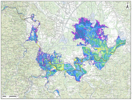
One of the fundamental parts of the project task was hydraulically modelling the existing and the future condition of the flood control system in the Kupa river basin region and compiling the map depicting areas under significant flood risk.
For that purpose, the previously developed Srednje posavlje simulation model has been improved. The devised simulation model covers the area of the Kupa River from Kamanje to the Sava mouth, the Korana River from Velemerić to the Kupa mouth, the Dobra River from Stativa to the Kupa mouth, the Mrežnica River from Mrzlo polje to the Korana mouth, the Kupa-Kupa channel as well as Kupčina and Odransko polje. The model was devised using the DHI Mike 11 application.
The results of the conducted simulations, amongst other things, also indicated the weak points of the existing flood protection system for the City of Karlovac, and were the basis for determining flood risks. In later phases of the project, the simulation model enabled the verification of various conceptual designs and their impact on reducing flood risk. The model continues to be available as a tool that can be used to determine the optimal sequence in constructing a flood protection system for the City of Karlovac.


